• Attractions
      • Back
      • Amusement Parks
      • Archaeology
      • Architecture
      • Art Galleries
      • Culture & Festivals
      • Forests & Jungles
      • Fortresses & Palaces
      • Hill-Tracts
      • Industries
      • Islands
      • Lakes
      • Land Ports
      • Libraries
      • Mountains
      • Movie Theaters
      • Museums
      • Parks & Zoos
      • Rivers
      • Sea Beaches
      • Stadiums
      • Tea States
      • Universities
      • Waterfalls
      • UNESCO World Heritage
  • Emergency & Services
      • Back
      • Airlines
      • Ambulance
      • Blood Banks
      • Fire Services
      • Foreign Missions
      • Hospitals
      • Police Stations
      • Security Services
      • Things To Avoid
      • Useful Words and Phrases
  • Agricultural Landuse
  • Agriculture Map
  • Agroecological Zones
  • Air Transport
  • Ancient Monuments
  • Archaeological Sites
  • Arsenic Contamination
  • Average Temperature
  • Bay of Bengal
  • Bio-Ecological Zones
  • Buddhist Vihara
  • Climate Map
  • Contour Map
  • Cropping Pattern
  • Cyclone Maps
  • Disaster Prone Areas
  • Earthquake Maps
  • Embankment Map
  • Flood Maps
  • Forests of Bangladesh
  • Forts in Bangladesh
  • Gas Blocks
  • Gas Fields & Gas Pipeline
  • General Soil Map
  • Geological Group Formation
  • Ground Water Zones
  • Historical Mosques
  • Land Ports
  • Landsat TM Image
  • Locations of Faults
  • Major Industries
  • Mineral Resources
  • Navigation Charts
  • Primary Power Grid System
  • Problem Soil Map
  • Railway Route Map
  • Rainfall Map
  • River Transport
  • Riverbank Erosion Map
  • Rivers of Bangladesh
  • Road Network
  • Rural House Pattern (1981)
  • Sectors of Liberation War
  • Soil Tracts
  • Tectonic Map
  • Wildlife Distribution

Barind Tract: Bangladesh

  • Map
  • Info

Map

Barind Tract Map Bangladesh

Map Courtesy: Banglapedia

Info

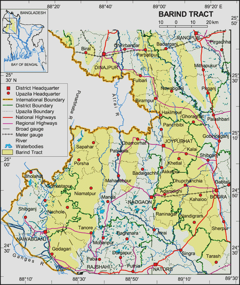
Barind Tract largest Pleistocene physiographic unit of the bengal basin, covering an area of about 7,770 sq km. It has long been recognised as a unit of old alluvium, which differs from the surrounding floodplains. In Bangla, it is spelled and pronounced as Varendra Bhumi. Geographically this unit lies roughly between latitudes 24°20´N and 25°35´N and longitudes 88°20´E and 89°30´E. This physiographic unit is bounded by the karatoya to the east, the mahananda to the west, and the northern bank of the ganges to the South. A lower fault scarp marks the eastern edge of the Barind Tract, and the little jamuna, atrai and Lower Punarbhaba rivers occupy fault troughs. The western part of this unit has been tilted up; parts of the western edge are more than 15m higher than the rest of the tract and the adjoining Mahananda floodplain. The southern part of the main eastern block of the Barind Tract is tilted down towards the southwest and passes under lower Atrai basin sediments in the south. The Barind Tract covers most parts of the greater dinajpur & rangpur districts of Rangpur division and bogra, joypurhat, naogaon, pabna and rajshahi districts of Rajshahi division.

Source: Banglapedia

Details
Last Updated: 06 September 2017
© The Bangladesh Network 2014 - 2026
Tourism Directory of BANGLADESH.
  • About
  • Contact
  • License
  • Privacy Policy
  • Terms of Use
Back to top